Biodiversity Stewardship
This page is an exploration of the biodiversity present at Stony Creek Farm. It is a documented study by Marian Dalke for the “Biodiversity Stewardship” course taught by Dr. Jim Egenrieder on behalf of Virginia Tech’s Online Masters in Natural Resources, June-August 2026.
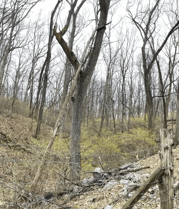
Spice bush light up the gully, March 2025
Photo Credit: Marian Dalke
Biodiversity is defined as the variety of life found within a specific region or biome. It can also refer to the genetic variety within a particular species.
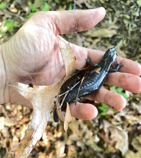
Salamander among the leaf mulch, May 2025
Photo Credit: Marian Dalke
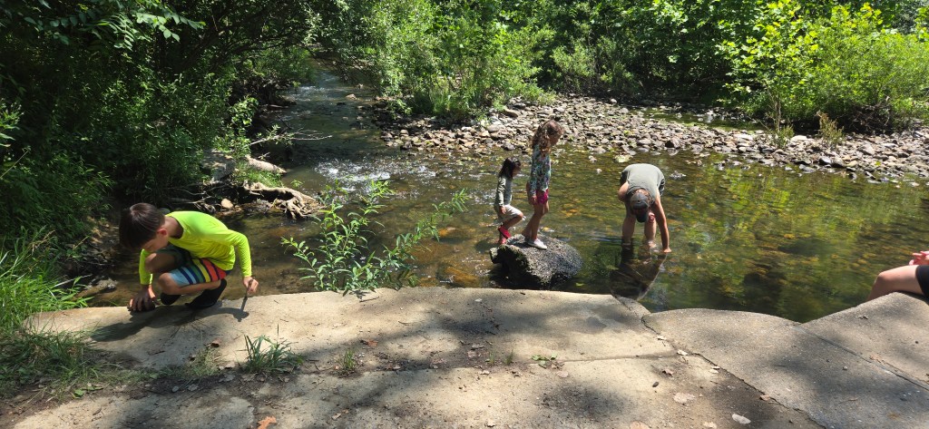
Stony Creek Farm is located near the town of Edinburg within Virginia’s Shenandoah Valley. This land has been in my family since 1956, when my maternal grandfather purchased the farm to raise cattle. The farm is roughly 180 acres in size and borders a stream (its namesake, Stony Creek). The land is 40% wooded and 60% pasture, including a dry ravine and a small pond. This mix of pasture, forest, and aquatic environments creates several unique habitats and ecotones for a variety of plant, animal and fungal species. The forest is a mixed temperate second-growth forest that was last logged in the 1960s, and consists primarily of hickories, oaks, red maples and black gum. The underlying geology is karst topography, which creates sinkholes and caves throughout the region.
I have chosen this study area since I have had a connection to this land since I was five. My family has countless stories of the plant and animal species who inhabit Stony Creek Farm and I would like to learn how to be better steward of this place on earth. My family continues to raise cattle on the farm and my father manages a six-acre apple orchard with 34 varieties of heritage apples. I am currently working with my father to create a plan to restore the pasture and manage the forest. Beginning in fall 2024, I installed a few experimental tree plantings throughout the property and hope to add more over time. By focusing on this area as my study site, I will further my own knowledge of the available biodiversity resources and prepare my own understanding of what is currently present on the site. This knowledge will inform future plantings and stewardship practices.
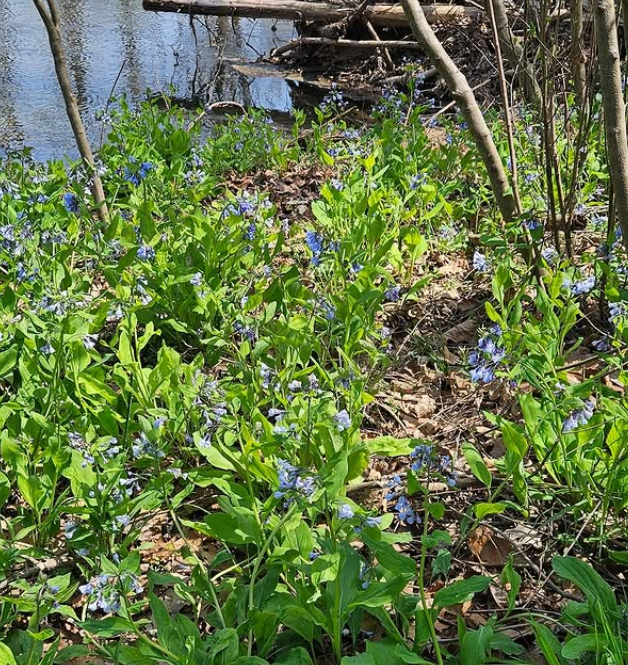
Bluebells bloom along the banks of Stony Creek, May 2025
Photo Credit: Marian Dalke
Stony Creek Farm lies within the Shenandoah Valley, between the Alleghany Mountains on the Virgina-West Virginia border and the Blue Ridge Mountains to the east. This is known as the “Ridge and Valley” region of Virginia. It is a part of the great Appalachian Mountain chain, recognized “as one of the most climate-resilient, biologically diverse, and carbon-rich landscapes in the world” (Nature Conservancy).
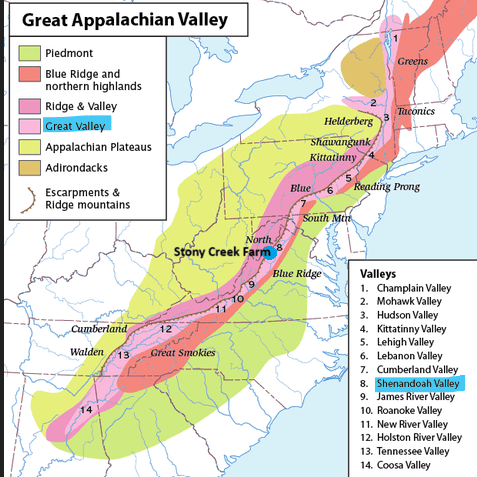
Stony Creek Farm is located about halfway within the 2,000 acre stretch of this mountain range, which runs from New Foundland, Canada to Alabama and is one of the oldest ranges on earth. This location makes it an important thorough fare for migration and movement of plant and animal species alike.
Photo credit: Animalia.bio.
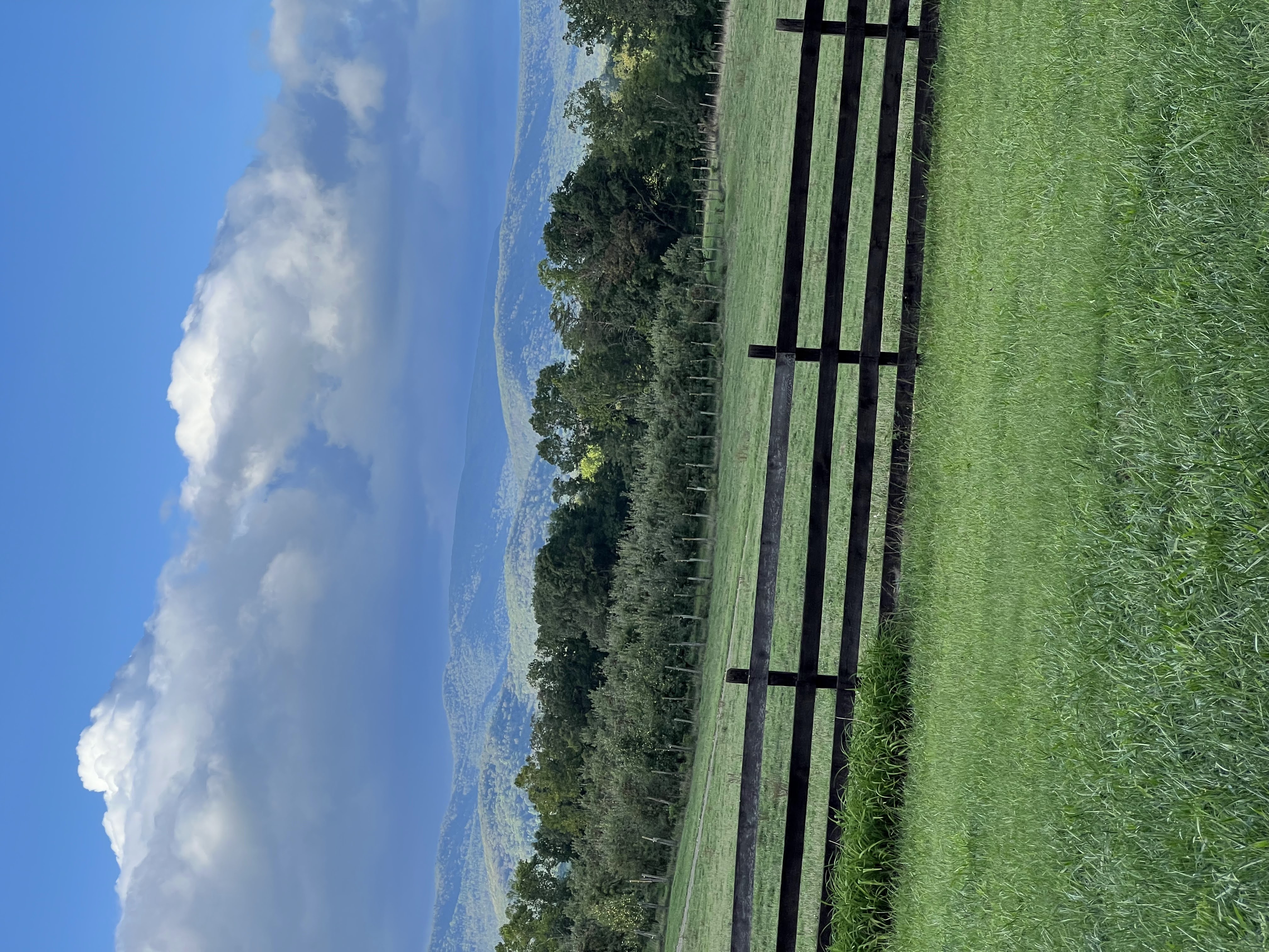
From the front porch of the farmhouse, you can look onto the North Mountain, particularly the peak of “Big Schloss,” named by early German settlers as the “Castle/Fortress.” The Valley is bordered to the east by Massanutten Mountain, and beyond by the Blue Ridge Mountains. This region is one of the driest in the state, which is why it led the nation in apple production during the early 20th century (due to reduced pest pressure).
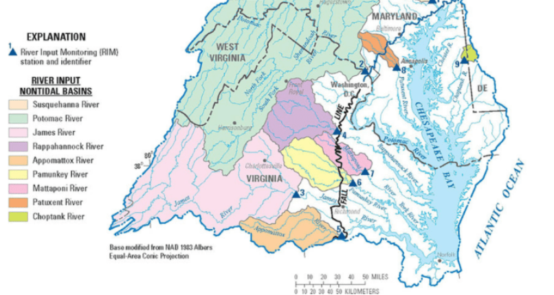
Stony Creek Farm is a part of the Chesapeake Bay Watershed. Stony Creek is a tributary of the North Fork of the Shenandoah River, which flows north and enters the Potomac River in Harpers Ferry and later empties into the Bay.
Photo credit: Thomas Jefferson Planning District Commission.
North Mountain, view towards West Virginia, July 2024
Photo Credit: Anne Dalke
The farm consists of varied habitats that support and sustain many plant, animal and fungi species. Please refer to the Flora and Fauna presentation below for more information about documented species at Stony Creek Farm!
I would be remiss if I didn’t mention the insect and arachnids that did not make it into the presentation: Ant, Caddisfly, Dragonfly, European sawfly, European hornet, Firefly, Golden orb spider, Gnat, Honeybee, Housefly, Japanese beetle, Junebug, Ladybug, Lantern fly, Mason bee, Mayfly, Monarch butterfly, Mosquito, Plum curculio, Samari wasp, Stinkbug, Stonefly, Swallowtail butterfly, Sweat bee, Ticks, Water-penny beetle, Wolf spider, and many many more!
I also want to recognize the many unnamed fungal, lichen and algae species upon which all life is possible.
Online mapping tools such as Google My Maps help illustrate the current biodiversity present at Stony Creek Farm, while enabling planning for future stewardship restoration projects.
I have created a map with three layers:
- Layer 1 represents the current habitats and land use of the farm.
- Layer 2 shows the general location of existing species listed in the flora and fauna presentation.
- Layer 3 indicates possible future restoration projects that would encourage and improve biodiversity of the site.
Virginia’s climate is humid and subtropical, spanning 27 unique ecoregions. The commonwealth encompasses six climate divisions; Stony Creek Farm falls within the Northern division (area 4 in the image).
Image Credit: Virginia Places.
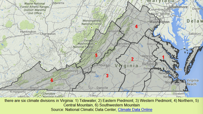
From 1991-2020, division 4 had a mean annual air temperature of 54.7 degrees Fahrenheit and a mean annual precipitation of 42.92 inches. When considered as its own region, the Shenandoah Valley typically averages 33-40 inches of rainfall. The Valley’s conditions are slightly cooler and drier than statewide (with averages of 56 degrees Fahrenheit and 45.83 inches of annual rainfall).
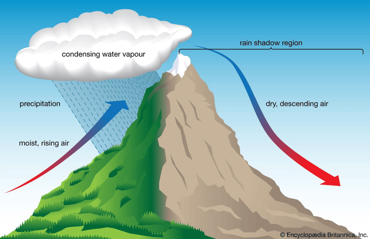
The Shenandoah Valley is impacted by the “rain shadow” effect wherein the mountains limit the rainfall on the leeward side of the mountain. Due to its location between North Mountain and Massanutten Mountain, Shenandoah County experiences two rain shadows creating a “semi-arid” climate.
Image Credit: Encyclopedia Britannica
I have experienced the rain shadow firsthand. In August 2024, my family and I went to West Virginia for the day where we were hit with several extreme thunderstorms. The minute we crossed the peak of Great North Mountain and entered Shenandoah County, the immediately rain stopped. When we got back to the farm that evening, there had been no rain at all that day, despite the heavy storms we experienced just across the mountain. According to my father, Shenandoah County is the driest county in the state, and his orchard is on the driest hill in the driest county.
Multiples sources track how climate in changing across Virginia and within the Northern climate division specifically. According to NOAA National Centers for Environmental Information, the “temperatures in Virginia have risen more than 1.5°F since the beginning of the 20th century.” George Mason University’s First Virginia Climate Assessment notes that although “there is an overall increase in temperatures across the Commonwealth, the coldest days are warming faster than the warmest days.” The report continues,
“If global emissions are reduced, warming over the 21st century will also be reduced. Daytime high temperatures are expected to rise by over 9°F (5°C) under a high emissions scenario (Figure 9b), while a lower emissions pathway would lead to an increase of roughly 5°F (3°C), or nearly half as much warming.”
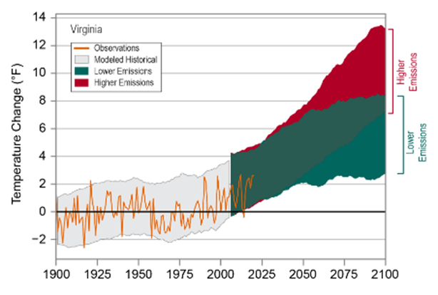
This graph from the NOAA National Center for Environmental Information shows temperature change since 1900 alongside climate predictions for higher and lower emission rates.
Regardless of temperature increase, all sources I consulted for this post predict an increase in flooding and drought throughout the state, as well as seawater rise in coastal areas. George Mason’s First Virginia Climate Assessment explains that
“Recent decades have seen many record-breaking multi-year droughts, including in 1999–2002, 2007–2008, and 2010–2012, as well as more recent shorter-duration droughts in 2023, 2024, and 2025. Drought is the second most expensive disaster in Virginia, behind only hurricanes and tropical storms.“
Personally, I remember the 1999-2002 drought as a child, when the town of Woodstock imposed water restrictions throughout the summer. These water restrictions were reinstated this year since Shenandoah County is currently experiencing a D1 (Moderate drought), following on the heels of severe droughts in 2023, 2024 and 2025.
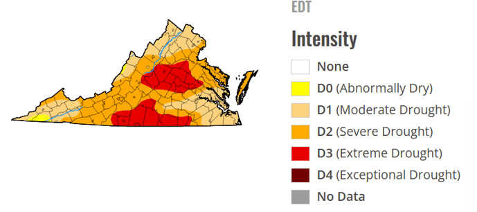
(U.S. Drought Monitor, July 2, 2026)
Although every year from 2023-2026 was designated as a drought, each had unique rainfall patterns. 2024 had a very dry spring and summer with wet hurricane storms in the fall (including Hurricane Helene which devastated North Carolina and Southwestern Virginia). 2025 was marked by a very wet spring with very little rain over the fall and winter months. 2026 started out with very little rain in the spring. Stony Creek received 3.9″ of rain in one week (May 20-26), followed by little rain in June (0.6″) until 1.7″ fell from 6/22-6/27. This illustrates the drought/flooding pattern that is current in effect as a result of climate change.
The impact of warming temperatures, riverine flooding and flash droughts has great impact on the agricultural economy of the Shenandoah Valley, and Stony Creek Farm specifically. Increased temperature leads to evaporation and drier soil conditions. This is a challenge in an area that relies on rainfall for hay and livestock production. The first hay crop for this year was drastically lower (estimate 40% reduction) due to the dry spring. Additionally, many farmers have had to feed hay to their cattle during the previous summers since the pastures were not producing enough forage due to drought conditions.
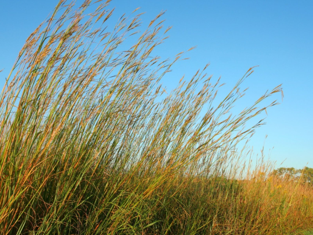
In order to prepare for these expected climatic shifts, there is renewed interest in planting native perennial grasses such as big blue stem (pictured above), switch grass and Indian grass. These grasses are native to this region and have very deep root systems that can access a shallower water table when water is scarce. They are also more prone to survive hot, dry conditions. Similarly, farmers are exploring stockpiling forages instead of cutting hay – thereby allowing the cattle to graze later into the winter for improved nutrition, as well as adding in other forages such as sorghum sudangrass to improve the soil structure and water retention.
The increased temperatures have drastically impacted fruit growers throughout the Valley. My father, Jeff Dalke, has seen an 100+ degree temperature swing in the first six months of 2026, from -3 degrees in January to 99 degrees in July. A warm March and April led to early blooming for fruit trees, only to be followed by three killing frosts the first week of April. The frosts arrived at a typical time for this region, but the plants bloomed early, resulting in a nearly 90% crop loss for vineyards and orchards in our region. This has severe economic consequences for the agricultural industry in our area. Unfortunately, it is difficult to consider alternative measures to prevent this, aside from some practices such as spraying water, wind (via windmills and helicopters), or fire (smudge pots) during a frost event which can be very costly and ineffective given the low freezes of recent years. It is clear that farmers and conservationists will need to employ both old and new strategies to adapt to a changing climate.
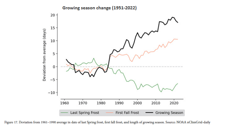
The graph shows the increased dates of the growing season, due to a later fall and spring frost.
Sources:
- Dalke, Jeffrey. (30 July, 2026). Re: Input for Grad Program [Email].
- Grymes, Charles. (6 July, 2026). “Climate of Virginia.” Virginia Places. www.virginiaplaces.org/climate.
- Ruess, P.J., Kinter, J., Ferreira, C.M., Ortiz, L.E., Ellis, A.W., Ermagun, A., Ezer, T., Fox, A. Klinger, B., Maggioni, V., Peterson, T., Allen, M., Burls, N.J., Cash, B., Clower, T.L, Costadone, L., Dollan, I.J., González-Dueñas, C., Henneman, R.F., Ho_man, J.D., Larson, M., Lindquist, H., Mitcham, M.B., Mitchell, M., de Lima, A.d.S, Tong, D., Ugliano, A., Whitehead, J. (2025). The First Virginia Climate Assessment. George Mason University. https://doi.org/10.13021/MARS/15226.
- Stevens L, Champion S, Stewart B, Frankson R, Sweet W, Rayne S. (2022). “State Climate Summary: Virginia.” NOAA National Centers for Environmental Information. https://statesummaries.ncics.org/downloads/Virginia-StateClimateSummary2022.pdf
- U.S. Drought Monitor. (6 July, 2026). “Virginia.” National Drought Mitigation Center. https://droughtmonitor.unl.edu/CurrentMap/StateDroughtMonitor.aspx?VA
- Virginia Tourism Corporation. (6 July, 2026). “Seasons and Climate.” Virginia is for Lovers. https://www.virginia.org/plan-your-trip/seasons-and-climate/
- Willett, Mason. (3 June, 2026). “Shenandoah Valley farmers face hay shortage amid drought.” WHSV3. https://www.whsv.com/2026/06/03/shenandoah-valley-farmers-face-hay-shortage-after-drought/.
The United States Department of Agriculture (USDA) began surveying the nation’s soils in 1899. Over the last 127 years, technicians and soil scientists have traversed the entire country in order to determine and classify each soil type. This information is available via the online resource WebSoilSurvey. It takes a bit of practice, but within a few minutes it’s easy to explore and dig deep to learn more about the soils that are under our feet.
I took some time to learn about the soils present at Stony Creek Farm. Below is a screen shot of the classifications throughout the farm.
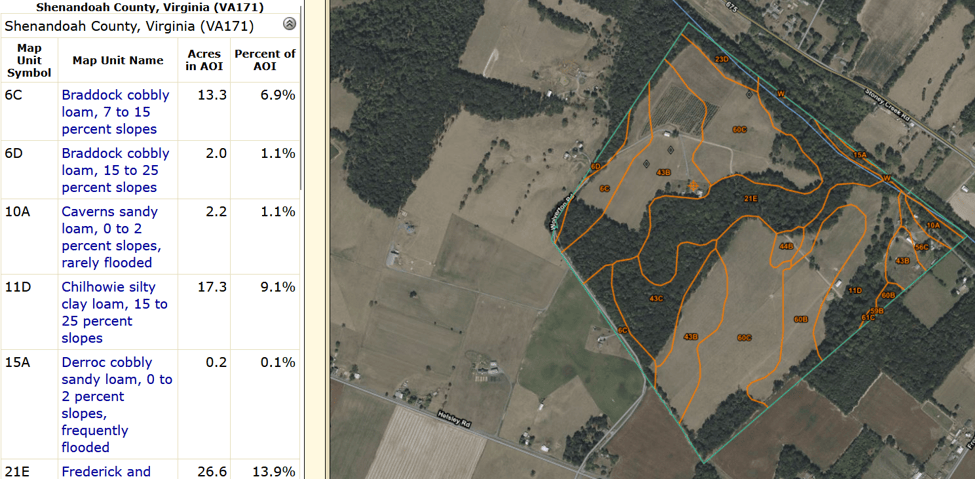
The primary soil classifications are:
- Unison gravelly loam (35.8%, 68.5 acres) – pasture
- Moomaw silty loam (27.6%, 52.8 acres) – primarily pasture, orchard
- Frederick and Poplimento (15.6%, 29.8 acres) – forest
- Chilhowie silty clay loam (9.1%, 17.3 acres) – pasture/forest
Each of these soil types is common in river valleys and is derived from parent material such as alluvium from either sandstone & shale (Moomaw) or acid crystalline rocks (Unison). Interestingly, the Moomaw soil series was established in Shenandoah County in 1988, meaning that it was first identified in this specific region.
In addition to soil tests, I like to establish a personal sense and feel for soil characteristics. I have noticed the silty and sandy loam texture of the soil at Stony Creek Farm, which is characteristic to Moomaw and Unison soil series. This is distinct from many other places I have farmed, where clay soils are more prominent. The only clay soils on the farm are in a primarily sloped, forested area with some pasture (11D). This silty and sandy texture correlates to the limited water retention and drought vulnerability of the farm.
The Frederick and Poplimento sites are primarily the forested portions of the farm. They have steeper slopes and rockier terrain, therefore they are not considered prime farmland. The parent materials are “residuum derived mainly from dolomitic limestone with interbeds of sandstone, siltstone, and shale.” The Frederick series is named for Frederick County, about 40 miles north of Stony Creek Farm, and the Poplimento series was established in Clarke County, just to the east of Frederick.
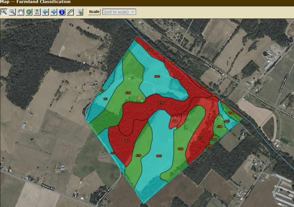
- The Moomaw series is regarded as prime farmland (green, 43B)
- The Unison series is considered farmland of state importance (blue, 60C).
- The Frederick and Poplimento series is not prime farmland, primarily due to the steep slopes of this terrain (red, 43C, 21E, 11D).
Image Credit: M. Dalke, 2026
As discussed in the above section on climate and weather, Shenandoah County is in a dry region of the state and has experienced successive severe droughts in recent years. The drought conditions are impacted by the soil types, which drain easily and do not retain water. The Moomaw series is known for its “fragipan” quality, wherein there is a hardened, impenetrable layer of soil that does not allow the water to permeate deeper into the soil. The USDA’s Soil Series Conditions describes Moomaw soils as “moderately well drained. Surface runoff is medium. Permeability is moderately slow or slow. Depth to the fragipan ranges from 15 to 30 inches.”
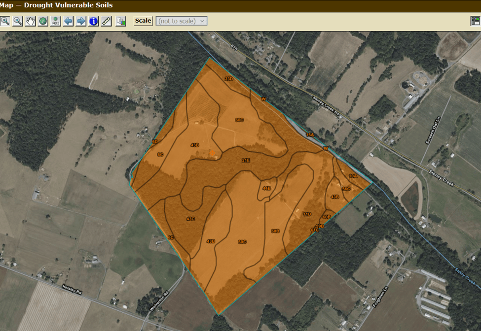
This image shows that the entirety of Stony Creek Farm is considered drought vulnerable. It is determined that “the soil and site properties are such that drought conditions generally occur every year. The soil may have low water storage capacity (5 to 15 cm) and the site may have low annual precipitation or high annual temperature or both.” As stated above, this designation correlates with the climate of the region as well.
Image Credit: M. Dalke, 2026
A key method to increase water retention is by improving the organic matter content of the soil. This is one way that human management can improve soil conditions and enhance the soil health of a landscape. Currently, Stony Creek Farm has an organic matter content between 1.5-2%, which is typical of most soils in the region. This is likely due to the fact that the land is in pasture and is not tilled regularly for crop production.
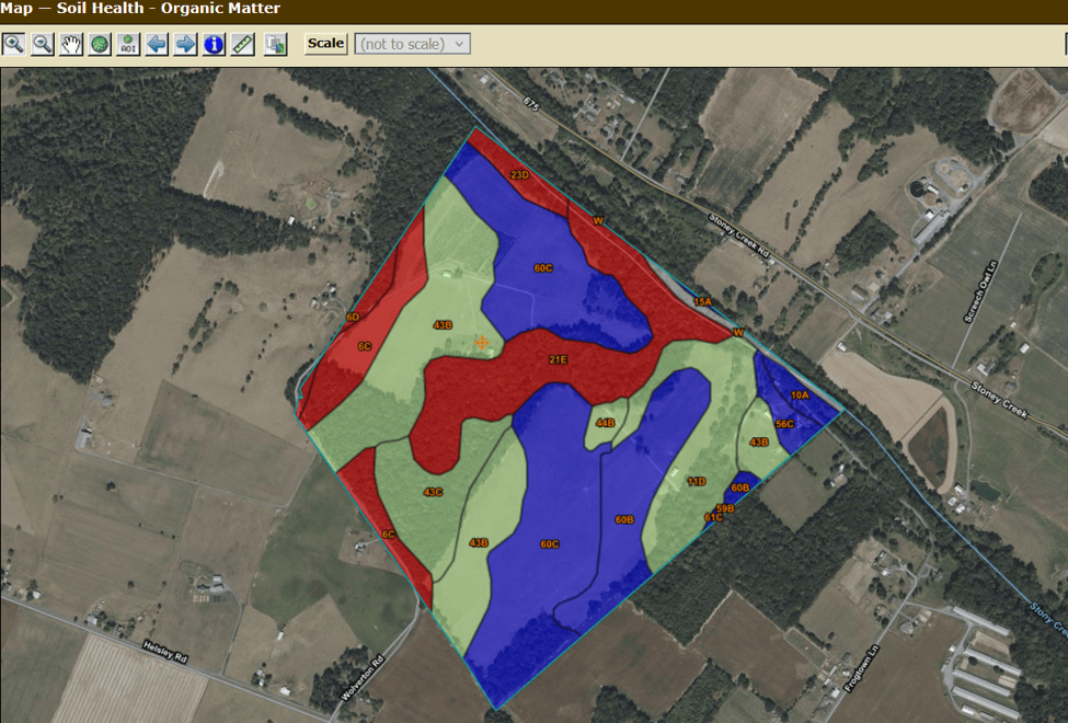
- Red is 1.5% organic matter
- Green 1.75% organic matter
- Blue 2% organic matter
Image Credit: M. Dalke, 2026
I have heard from a farmer in our county that prior to European colonization, organic matter content in the Valley soils was closer to 6-10%. I know of two farmers in the Valley who have achieved these levels through intensive soil heath practices such as rotational grazing of livestock and organic matter inputs (compost, mulch, and compost teas). It is encouraging to know that with the appropriate management strategies, it is possible to increase organic matter content, which will reduce the drought susceptibility of this farm.
Web Soil Survey also helps identify Ecological Classifications. The map indicates two primary ecological sites on the farm:
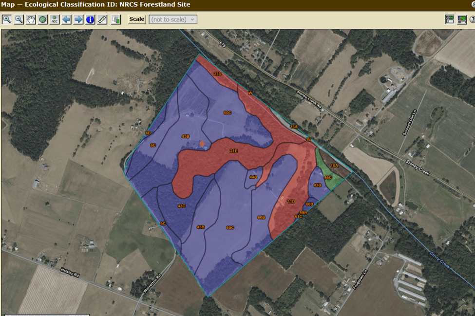
- Loamy to Coarse terrace – (purple) known for sugar maple, white ash, american hornbeam and may apple
- Mixed limestone upland – (red) known for chinquapin oak, white oak and black haw viburnum
Image Credit: M. Dalke, 2026
I have documented some of these species on Stony Creek Farm (may apple, white & chinquapin oaks and black haw viburnum). I will keep an eye out for the other species. It is unlikely that I will find white ash given the emerald ash borer’s presence in the area. Sugar maples are more prominent in the highland areas to the southwest of Stony Creek Farm, and are also facing pressure due to rising temperatures as a result of climate change.
It is clear that there is a wealth of information available at Web Soil Survey. I am sure that I will consult this resource in future years to assist in stewardship of Stony Creek Farm.
Sources:
- Edmonds, W. J., D. D. Rector, D. A. Gall, D. R. Hatch, R. S. Joslyn, and J. C. Baker. (1987, Accessed 9 July, 2026). “Moomaw series.” National Cooperative Soil Survey. https://soilseries.sc.egov.usda.gov/OSD_Docs/M/MOOMAW.html.
- Murdock, Lloyd. (June 21, 2024). “Fragipan horizon changes using annual ryegrass and other amendments.” Open Journal of Soil Science. https://www.ars.usda.gov/research/publications/publication/?seqNo115=415686.
- Natural Resources Conservation Services. (June 25, 2024). “Exploration, Invention, and Evolution Still Abound After 125 Years of Soil Surveys.” https://www.nrcs.usda.gov/news/exploration-invention-and-evolution-still-abound-after-125-years-of-soil-survey.
- Soil Survey Staff, Natural Resources Conservation Service, United States Department of Agriculture. Web Soil Survey. Available online. (Accessed 7/9/26.)
- United States Department of Agriculture. “Frederick Series.” National Cooperative Soil Survey. (Accessed 7/9/26). https://soilseries.sc.egov.usda.gov/OSD_Docs/F/FREDERICK.html.
- United States Department of Agriculture. “Loamy to Coarse Terrain.” Ecological Site Concept. (Accessed July 9, 2026). https://edit.sc.egov.usda.gov/catalogs/esd/147X/F147XY007PA/model.
- United States Department of Agriculture. “Mixed Limestone Upland.” Ecological Site Concept. (Accessed July 9, 2026). https://edit.sc.egov.usda.gov/catalogs/esd/147X/F147XY003PA.
- United States Department of Agriculture. “Poplimento Series.” National Cooperative Soil Survey. (Accessed 7/9/26). https://soilseries.sc.egov.usda.gov/OSD_Docs/P/POPLIMENTO.html.
- United States Department of Agriculture. “Unison Series.” National Cooperative Soil Survey. (Accessed 7/9/26). https://soilseries.sc.egov.usda.gov/OSD_Docs/U/UNISON.html
Please explore this overview of native and non-native species at Stony Creek Farm, including an invitation to re-frame how we consider these terms.
My introduction to naturalist study was spending 8 years at Nature Camp as a camper and counselor from ages 10-18. Nature Camp is an educational overnight camp in the George Washington National Forest of Virginia, where students take classes in all sorts of natural study, including mycology, limnology, entomology, botany and more. As a part of camp, all students write reports about the different species they observe in the forests, meadows and streams around camp. At the end of every session, campers cram into the library, a wooden building with wall-to-wall screened windows. The smell of dusty books emanates alongside the surrounding damp forest air. Campers pour over field guides to identify the species they had seen throughout their stay.
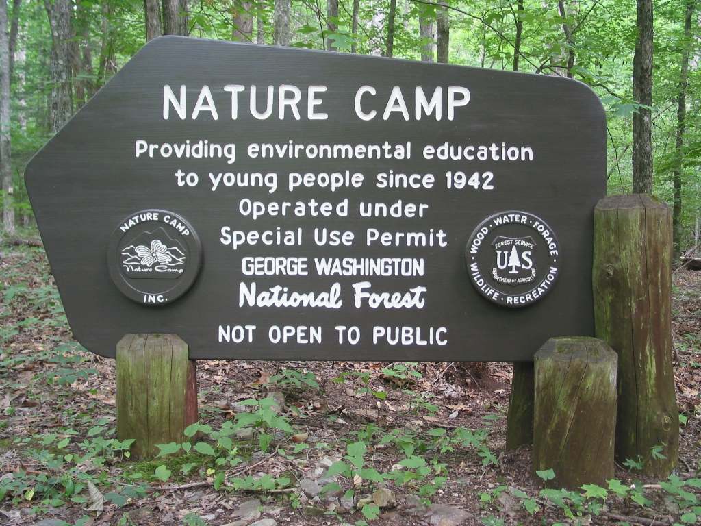
This sign has welcome campers to Nature Camp for over 70 years (including my mother, brother, cousin and me)!
Photo Credit: Nature Camp Facebook Page, 2025
This is how I was trained in natural study and I have been resistant to using phones as a source of identification ever since. I have often felt that I did not want to rely on my phone to interpret the world around me. Using my phone felt like an unwanted intervention into my experiences with nature. I enjoy using field guides because it helps hone my own sense of identification and observation. If I simply take a picture and wait for the phone to tell me what it is, I’m not really developing my own deduction, knowledge and understanding. I love leafing through a field guide and learning about other species as I flip through the pages.
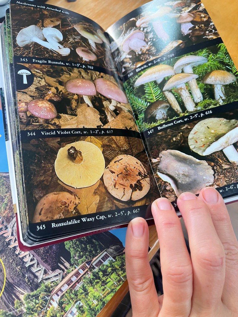
Looking up mushrooms!
Photo Credit: Marian Dalke
This week my daughter and I went on a hike and encountered at least 6 different mushroom species. We came back home and took out the books. Of the 6 mushroom species, I only identified 2 at home (a bolete & viscid violet cort). The challenge with field guides is that it’s hard to rely on memory if you don’t bring the specimen home with you – or haul the heavy books into the field. Another downside to field guides is that they take more time to use (though this can be important to overall learning), and that they cost more money. I can see that this is a barrier for someone who is just starting out in naturalist study. In this way, the apps make species identification more accessible to more people.
Field guides are also often limited to one region and may not have up to date species that have been recently introduced. An example of this is a plant that showed up in our lawn this spring. It had pale, fuzzy and spotted leaves and stems with sharp hairs. I got the sense it was in the borage family, based on my knowledge of that plant from gardening. As the plant bloomed, it also had light blue borage-colored flowers, and it began to create tall seed pods with tiny black seeds. I searched online and tried to identify this plant using different descriptive terms but did not come up with anything. Eventually, I sent a picture to a colleague at the Natural Resource Conservation Service who used the Seek app to identify it. At first, since it was in the flowering stage, Seek gave her a different plant ID. Eventually we deduced it was viper bugloss, an introduced species in the borage family. While I was pleased that I had known the plant family, my knowledge was limited up to that point. In either case, it’s important to keep a humble, open mind and know that both the field guides and the apps may be incorrect. She recommended that I remove it along with the seeds, which I did.
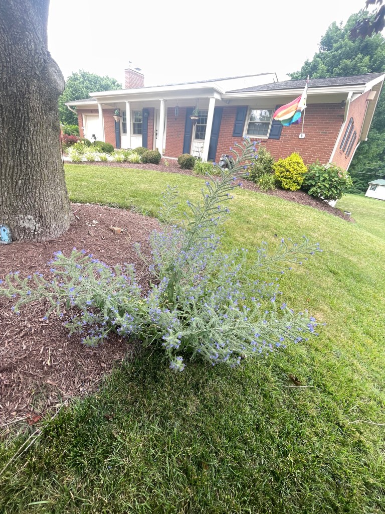
Viper bugloss in bloom (Echium vulgare)
Photo credit: Marian Dalke
One area that I have not excelled at is bird song identification. My uncle B Dalke was very skilled at this and he and his wife Sylvia have traveled the world learning about and identifying birds. I wish I had learned more from him before he passed away in May of this year. This summer I finally downloaded the Merlin app from Cornell, which I’ve always heard good things about. It was six in the morning when I sat on my porch in Harrisonburg, VA and opened the app. The first bird to register was the Eastern Wood Pee-Wee – the very same bird I had pointed out to my daughter last night on the porch. This was followed soon after by a red-shouldered hawk call, from the same hawk we have been observing since last winter. It was fun to see the other bird calls register and highlighted on the app. Within about 10 minutes, the app had recorded 12 different species, primarily forest song birds, which makes sense given our location near a forested park. It was encouraging to recognize many species I have seen around the house, such as goldfinches and chickadees, as well as those I hadn’t – like the red-eyed vireo and eastern gray catbird. I like how you can click on each species to learn more about its range and habitat, as well as listen to its song again. This will help deepen my knowledge and identification skills. I will certainly use this app in the future to help deepen and extend my knowledge of birds in my area.
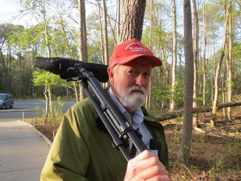
My Uncle B setting out for a day of bird watching!
Photo credit: Sylvia Dalke
My take away from this study is that although I will continue to use the traditional field guides in many cases, there are ways that the new technologies can pull us deeper in relationship with the natural world, rather than cutting us off from it. I recently attended an event with a colleague who is a bird biologist from the Smithsonian Institute. I was amazed by his ability to identify birds- even while holding a conversation. His ears were tuned in and able to pick up the subtle bird calls, including a meadowlark. I may not be able to reach his – or my Uncle B’s – level of identification, but I look forward to using the Merlin app (along with my weathered field guides) to assist me along the way.
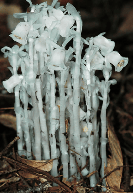
I have long been fascinated by the ghost pipe (Monotropa uniflora), a parasitic plant that has no chlorophyll and is therefore entirely white. I spotted some growing on a forested hillside at Stony Creek Farm in July 2026 and decided to use this species as the subject of my Taxonomy assignment.
Photo credit: Gary Monroe, USDA Forest Service
Through this assignment, I was introduced to a new term, “clade,” which has been in use since the 1950s and has recently replaced the traditional taxonomy of Linneaus. Each clade shows various evolutionary branches that lead to the specific genus and species. As scientists explore genetic material, they create new clades within a previous one.
Photo credit: Wikipedia
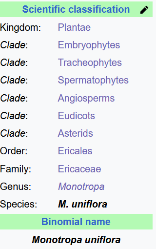
- Domain: Eukaryota – Organisms with cells that have membrane-bound nucleus, including all animals, plants, and fungi.
- Kingdom: Plantae – Predominately multicellular, photosynthetic organisms.
- Clade: – Embryophyta – Land plants that are multicellular and have reproductive organs that reproduce via seed or spores.
- Clade: Tracheophytes – A plant with vascular tissue (i.e. xylem and phloem) to transport water and minerals and photosynthesize. Vascular plants have roots, leaves and stems. This clade consists of most land plants except mosses.
- Clade: Spermatophyte – A vascular plant that produces a seed.
- Clade: Angiosperms – Meaning, “covered seed,” angiosperms are flowering plants that bear fruit with a seed inside. This is the most diverse group of land plants, including forbs, grasses, trees, shrubs and vines, as well as aquatic plants.
- Clade Eudiocts – Flowering plants with two cotyledons (i.e. seed leaves) and tricolpate pollen (grooved structure).
- Clade Asterids – Flowering plants that include 17 orders and 80,000 species, comprising one third of total flowering plants. The majority of these plants have fused petals (corolla tube) and few stamens.
- Order: Ericales – Flowering plants that include trees, bushes, lianas and herbaceous plants including chlorophyll-deficient plants. Commonly have mycorrhizal associations and fused petals (corolla tube).
- Family: Ericaceae – Heath/heather family of flowering plants common in acidic soils; includes over 4,000 species including cranberry, blueberry, huckleberry and rhododendron.
- Subfamily: Monotropoideae – Subfamily known for mycoheterotrophic characteristics (i.e. they do not contain chlorophyll and do not photosynthesize, but instead rely on parasitic relationship with fungal hosts in the Russulaceae family).
- Genus: Monotropa – Includes five species of herbaceous flowering plants that do not contain chlorophyll and therefore rely on parasitism. Name means “once turned”
- Species: M. uniflora – A parasitic, non-photosynthesizing perennial plant of North America, South America and East Asia. White in color, with some pink or red coloration, ghost pipe reaches 2-12 inches in height. Name means “one flowered.”
(Summarized from Wikipedia entries for each)
Citations:
- Encyclopedia Britannica. (Accessed 21 July 2026). “Eudicots.” https://www.britannica.com/plant/angiosperm/Eudicots#ref1279218.
- Kew Royal Botanic Gardens. (Accessed 21 July 2026). “Monotropa uniflora.” Plants of the World Online. https://powo.science.kew.org/taxon/281016-2.
- Pavitt, D. (24 July, 2023). “From Ranks to Clades – the Old and New of Taxonomy.” The Average Scientist. https://theaveragescientist.co.uk/2023/07/24/from-ranks-to-clades-the-old-and-new-of-taxonomy/.
- United States Department of Agriculture. (Accessed 21 July 2026). “Monotropa uniflora- Ghost Plant, Indian Pipe.” USDA Forest Service. https://www.fs.usda.gov/wildflowers/beauty/mycotrophic/monotropa_uniflora.shtml.
Dendrology is the study of trees. This presentation explores several shrub, coniferous, deciduous and fruiting tree species present at Stony Creek Farm. The trees are organized into four categories and alphabetized by family name.
Note: The information in the common products/uses section is based on knowledge I have gained over many years from naturalists, botanists, and family members who have first hand experience with these tree species.
The following presentation is an overview of Friends of the North Fork of the Shenandoah River, a local organization working to advance watershed health for the North Fork of the Shenandoah River and its tributaries, including Stony Creek.
The health of the river is directly correlated to the health and well being of the farm and its surrounding communities. By caring for the land and water, by extension, we care for one another – and all the interconnected species present at Stony Creek Farm and the wider Shenandoah Valley region.
The final assignment of the Biodiversity Stewardship course was learning how to create a non-profit organization in our state. Although Stony Creek Farm is currently a for-profit farm enterprise, I am curious to explore the future possibility of creating a non-profit educational center housed on site. Below are my findings and initial ideas.
General research:
Non-profit organizations in Virginia are known as “non-stock corporations,” because even though they have members, no one owns stock in the enterprise.
The Virginia Chamber of Commerce estimates that it takes two weeks to three months to complete the tasks listed below. The associated costs of incorporation are roughly $400-$1,000 total.
There are three separate entities with required paperwork to apply for non-profit status.
- Internal Revenue Service (IRS)
- State Corporation Commission (SCC)
- Virginia Department of Agriculture and Consumer Services (VDACS)
Steps to create a non-profit in Virginia:
- Select a name and ensure that it has not already been used by another organization via the name availability search.
- My proposed name, Stony Creek Sanctuary, has not yet been selected.
- Next, assign a registered statutory agent in Virginia who will accept legal papers on behalf of the organization.
- Then, select at least three board members who can also serve as the officers: president, vice-president and treasurer.
- Board members must serve a minimum of one year term.
- The directors are in addition to the incorporator.
- Create the organizational structure with the board members:
- Decide on the organization’s mission, vision and values.
- Create by-laws and conflict of interest policy to keep on record for internal management.
- Decide the corporate/organizational structure such as a non-profit public benefit corporation, trust or association.
- Prepare and file articles of incorporation.
- Federal
- Obtain an Employer Identification Number (EIN), a 9-digit unique identifier from the IRS, by completing Form SS-4.
- Apply for tax-exempt status with the IRS via Form 1023.
- State
- Create an account at this link: SCC819.
- Apply for Virginia state tax exemption to obtain sales and use tax exemption.
- Complete the Charitable solicitation form on the VDACS website.
- Create an account at this link: SCC819.
- Federal
- Other tasks:
- Open a bank account and get an accountant.
- Submit annual report to VDACS and IRS and sign necessary legal documents.
- Create a website to communicate the organization’s message.
- Solicit donations and grants.
- Do the dern thing!
Draft of vision, mission and values:
Name: Stony Creek Sanctuary – A place of community and climate resilience.
Vision: A living ecosystem of right relationship that supports an interconnected ecology of beings who live, learn and play together to maintain and preserve agrarian knowledge and practice.
Mission: Serve as a learning laboratory that provides intergenerational education and training in agroecological practices through the stewardship of farmland, forestland, and waterways while maintaining and passing on the cultural heritage of agrarian communities.
Values: Stewardship, collective liberation, solidarity economics, continuing revelation, playfulness, responsibility and discipline.
Activities:
- Forest
- Identify species
- Invasive/Introduced species management
- Woodland botanical plantings
- Low-impact forestry
- Farm
- Orchard maintenance
- Pasture renovation
- Meadow planting
- Silvopasture plantings
- Incubator farm plots for new agrarians
- Waterways
- Stream monitoring
- Riparian buffer maintenance
- Pond botanical plantings
- Education
- Workshops on cultural food ways and ecological stewardship
- Day camp
- Retreat space
- Apprenticeship
Infrastructure development:
- Signage
- Trail building
- Timber frame pavilion
Timeline: The rest of my life 🙂
Notes: There are a lot of remaining questions to explore, such as land ownership agreements, finance and governance structure, materials and personnel assessment, and sunsetting/transition plan.
Sources:
- Chamber of Commerce. (Accessed 30 July 2026). “How to Start a Nonprofit in Virginia (2026 Guide). https://www.chamberofcommerce.org/nonprofit/virginia.
- Virginia Department of Agriculture and Consumer Services. (Accessed 30 July 2026). “Charitable Solicitation Registration.” https://www.vdacs.virginia.gov/food-charitable-solicitation.shtml.
- Virginia State Corporation Commission. (2 February 2026). “Virginia Nonprofit Organization Toolkit.” https://www.scc.virginia.gov/media/sccvirginiagov-home/business-home/forms-and-fees/virginia-nonstock-corporations/nptoolkit.pdf.
When choosing a Masters Program, a key goal of mine was that it be relevant and connected to my personal interests to steward Stony Creek Farm. I am grateful for the project-based approach of this class, which granted me the time and encouragement to explore this subject matter in depth. At times, I felt that the assignments served as an inventory of existing knowledge (such as the flora and fauna presentation), while others required additional research (climate & weather and web soil survey). It is a tremendous opportunity to have been able to compile all of this information in one place. It has also given me the chance to further develop tools that are relevant in my line of work. As a Small Farm Agent with Virginia Cooperative Extension, I advise landowners in how to care for their properties. By gaining firsthand experience with the tools in this class- such as web soil survey, google my maps, and U.S. Drought Index – I am better prepared to assist producers and land owners in assessing the ecology of their farms and forests.
Another meaningful aspect of the class was sharing it with family for their input. I sent the webpage to my parents, siblings, aunts, uncles and cousins to get their feedback. I also shared it with Laura Bennett, the Executive Director of the Friends of the North Fork of the Shenandoah River. Both Laura and another family member expressed their specific interest in my personal observations and stories related to the land. As Laura mentioned, “I think your personal connection to the farm makes the information more comprehensive and engaging” (personal communication, July 29, 2026). Laura also invited my family and I to assist with stream monitoring activities on site. This would be a direct way to continue assessing stream health as it relates to stewardship practices of Stony Creek Farm, and to engage the next generation of land stewards from my family – my daughter and her cousins.
I’m grateful for the chance this course provide to learn and explore about a place I care about deeply. I know I will continue to do so in the coming years.